
Table of Contents >> Show >> Hide
- Where Exactly Is Triton Island, and Why Does It Matter?
- From Sandbar to Strategic Outpost: What the Satellites Show
- The 2024 Upgrade: Radar, Missiles, and More Military Hardware
- Why Would Beijing Want an Airstrip Here Anyway?
- How Vietnam, Taiwan, and the U.S. Are Reacting
- What International Law Says and What It Doesn’t
- What Triton Means for the South China Sea Balance
- Experience and Lessons from Other Island Militarization
- Conclusion: A Tiny Island with Outsized Consequences
If you zoom in far enough on the South China Sea, the map starts to look like sprinkled sand. One of those “grains” is Triton Island a tiny speck that most people couldn’t find on a globe even with a magnifying glass. Yet this little island has suddenly become the center of big-power drama, satellite sleuthing, and a lot of worried diplomats.
In recent years, satellite images have shown China turning Triton Island from a lonely sandbar into a fortified outpost, complete with new buildings, hardened infrastructure, radar systems, and what many observers first believed was a military airstrip. Whether it’s technically a full runway or not, the direction of travel is obvious: Triton is being remade into a serious military node in one of the world’s most contested seas.
Where Exactly Is Triton Island, and Why Does It Matter?
Triton Island sits in the southwestern corner of the Paracel Islands, roughly midway between Vietnam’s central coast and China’s Hainan Island. On a map, it looks almost laughably small, but its location is anything but a joke. It lies close to key shipping lanes and fishing grounds in the northern South China Sea, in waters claimed by China, Vietnam, and Taiwan.
China calls the island Zhongjian Dao, Vietnam calls it Đảo Tri Tôn, and Taiwan also considers it part of its historic maritime territory. China has occupied the island for decades and treats the Paracels as an integral part of its territory, but Vietnam and Taiwan formally protest that claim. This mix of overlapping sovereignty claims, valuable resources, and military posturing is why a strip of sand just a couple miles across now matters on a global scale.
For Beijing, Triton Island helps extend a defensive (and offensive) network stretching from Hainan down through the Paracels and onward to heavily built-up outposts in the Spratly Islands. For Vietnam and other regional states, it’s another step in what they see as a creeping, “salami-sliced” effort to turn disputed waters into de facto Chinese-controlled space.
From Sandbar to Strategic Outpost: What the Satellites Show
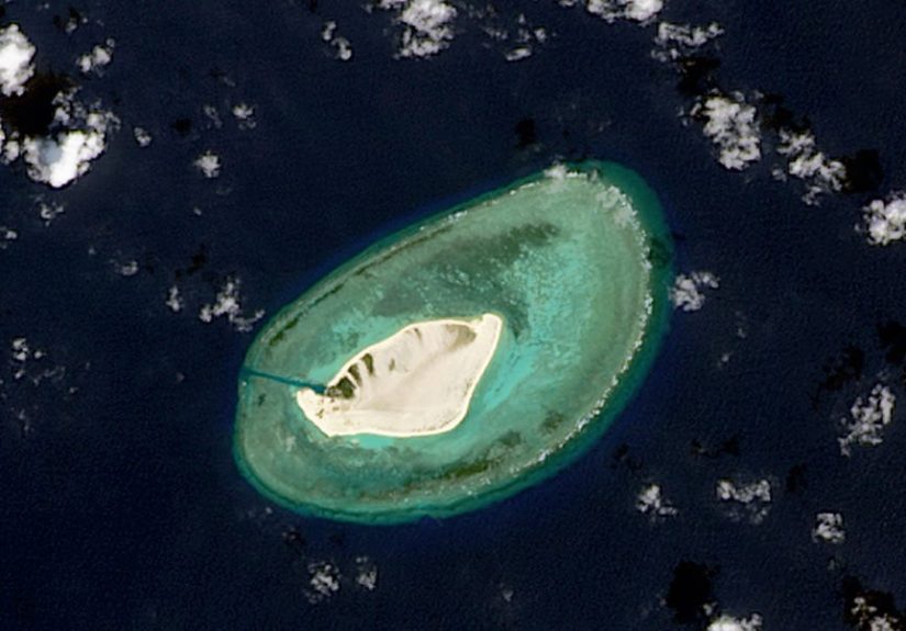
Up until the early 2010s, Triton Island was mostly famous for being remote, sandy, and occasionally used for propaganda slogans visible from the sky. That changed as China accelerated construction across the South China Sea. By the mid-2010s, analysts began noticing land reclamation, new sea walls, and more permanent facilities dotting the island.
In mid-2023, commercial satellite images revealed something new and eye-catching along Triton’s southern edge: a long, straight, pale strip cutting across the sand. Estimates put the structure at roughly 600 meters in length far smaller than China’s full-length 3,000-meter runways on places like Woody Island and several Spratly reefs, but still long enough to spark speculation that Beijing was adding yet another airstrip to its growing network of island runways.
Early media coverage called it an “airstrip” or “runway,” pointing to the straight alignment, leveled surface, and the presence of construction equipment and vehicle tracks. The idea that China was quietly building a new military landing strip within striking distance of Vietnam and along important sea lanes prompted immediate concern in Washington, Hanoi, and Taipei.
Is It Really an Airstrip?
Here’s where things get more complicated and a bit nerdy.
Specialists in satellite imagery and maritime strategy quickly pointed out that the strip on Triton Island is unusually narrow, around 15 meters wide according to several analyses. That’s much thinner than the standard width for a runway that would handle fighter jets, large transports, or heavier surveillance planes. Some experts argued the feature looks more like a raised road, levee, or logistics strip than a full-fledged runway.
Think of it as the difference between a city airport and a long driveway: both are straight and paved, but only one is meant to land airplanes safely. In this view, the “airstrip” might be better understood as part of a broader engineering project elevating key areas against storms, supporting construction vehicles, or creating a platform that could later host small aircraft, helicopters, or drones rather than full-sized jets.
Other analysts caution that, regardless of the exact label, the structure still enhances China’s ability to move equipment and personnel around the island. And if parts of the strip are strengthened later, it could become more useful to light aircraft or unmanned aerial vehicles (UAVs). In fast-moving military innovation, today’s narrow road can easily become tomorrow’s launch pad.
The 2024 Upgrade: Radar, Missiles, and More Military Hardware
While the world was debating whether Triton’s new feature counted as a runway, new imagery in 2024 shifted the conversation. Analysts began spotting distinctive, hexagon-shaped arrays, domed structures, and support buildings that resemble advanced radar installations and electronic intelligence systems.
Research from independent think tanks and defense-focused outlets suggests that China is installing a sophisticated “counter-stealth” radar system on Triton Island, designed to track aircraft that are normally difficult to detect, such as stealth fighters or certain long-range bombers. Additional facilities appear consistent with signal intelligence collection essentially, powerful “ears” and “eyes” that can monitor communications and activity across a broad swath of the northern South China Sea.
Some assessments also point to what look like missile pads or staging areas that could support anti-ship missiles. That combination long-range radar and possible anti-ship weapons fits neatly into China’s broader strategy of building an anti-access/area denial (A2/AD) network. The idea is to make it riskier and more costly for foreign navies and air forces, especially those of the United States and its allies, to operate close to China’s claimed waters.
In practical terms, Triton Island is evolving from a simple garrison into a mini-hub for sensing, tracking, and potentially targeting foreign forces. Whether or not aircraft actually land there, the island will almost certainly play a role in guiding aircraft and ships operating from other bases, like the major airfield on Woody Island to the northeast.
Why Would Beijing Want an Airstrip Here Anyway?
Even if the “airstrip” is more of a heavy-duty road, the logic behind adding aviation-related infrastructure to Triton Island is straightforward.
- Better logistics: A hardened strip makes it easier to move supplies, fuel, and personnel across the island, especially during storms or high seas. That keeps the outpost functioning as a permanent base rather than a temporary camp.
- Helicopters and drones: A 600-meter prepared surface is more than adequate for helicopter operations and many types of unmanned aircraft. Drones don’t need a huge runway; they just need reliable launch and recovery space.
- Redundancy: Even if larger aircraft rely on Woody Island or mainland bases, Triton can serve as a backup for emergency landings, small planes, or short takeoff and landing (STOL) aircraft in a crisis.
- Symbolism: Concrete on sand sends a political message. It signals long-term intent to stay, regardless of protests or diplomatic pressure.
For China, the island helps fill a coverage gap between Hainan and its other South China Sea outposts, creating overlapping zones of radar, communications, and patrol routes. From a purely military planning perspective, if you can plug a hole in your surveillance network with a small strip of land, why wouldn’t you?
How Vietnam, Taiwan, and the U.S. Are Reacting
Unsurprisingly, not everyone is thrilled about Triton’s transformation.
Vietnam has been particularly vocal, issuing formal diplomatic protests and highlighting that Triton lies well within what it views as its exclusive economic zone (EEZ). Vietnamese officials argue that China’s construction violates international law and undermines regional stability. Taiwan, which also claims the Paracels, has raised its own objections, though its voice is often overshadowed by the louder Beijing–Hanoi dispute.
The United States doesn’t take a position on the ultimate sovereignty of the island, but it strongly opposes any unilateral militarization that changes the status quo. Washington has long warned that China’s construction boom in the South China Sea from reclaimed reefs to hardened airbases risks turning the region into a heavily armed chessboard. U.S. Navy ships continue to conduct “freedom of navigation” operations (FONOPs) near contested features, signaling that the U.S. does not accept excessive maritime claims.
For Southeast Asian neighbors like the Philippines or Malaysia, Triton Island is another reminder that what happens in one part of the South China Sea rarely stays there. When one disputed island becomes a radar hub or missile site, it changes the calculations for everyone operating anywhere near that network.
What International Law Says and What It Doesn’t
Legally, Triton Island lives in a somewhat murky space. Under the United Nations Convention on the Law of the Sea (UNCLOS), naturally formed islands can generate territorial seas and, in some cases, economic zones. But those rights depend on disagreements about who owned what, and when and the South China Sea is full of such disagreements.
A 2016 international arbitration ruling in a case brought by the Philippines against China rejected Beijing’s sweeping “nine-dash line” claims in the Spratly Islands. However, the ruling did not directly address the Paracels, where Triton sits. China, for its part, rejected that decision outright and continues to insist on what it calls “indisputable sovereignty” over most of the sea.
The result is a patchwork of claims and counterclaims. Vietnam points to historical use and French colonial-era maps. China cites ancient navigation records and modern control. Taiwan’s position shadows that of the pre-1949 Republic of China. Meanwhile, international law scholars stress that constructing military infrastructure on disputed land doesn’t magically settle sovereignty it just raises the stakes.
What Triton Means for the South China Sea Balance
You can think of Triton Island as one more node in a growing network of sensors, airfields, ports, and missile sites that now dot the South China Sea. Each individual outpost may seem small, but together they create a lattice of overlapping capabilities: radar coverage, air defense, anti-ship strike potential, and logistical support.
From Beijing’s perspective, this network helps secure vital sea lanes, protects its southern flank, and complicates any foreign military operation in the region. From the perspective of the United States and many of China’s neighbors, it looks like a slow-motion militarization of a shared maritime space, backed by concrete and rebar instead of treaties and compromise.
Either way, Triton Island sends a clear message: even tiny pieces of real estate can have outsized strategic impact when placed in the middle of contested waters. What happens on a sandbar today may shape how navies and air forces maneuver tomorrow.
Experience and Lessons from Other Island Militarization
Triton Island is not Beijing’s first rodeo when it comes to turning reefs and rocks into fortified outposts. Looking at earlier cases helps us understand what might come next and what countries in the region have already learned the hard way.
From Spratly Reefs to Full-Fledged Bases
In the Spratly Islands, China previously took what were essentially submerged reefs and transformed them into sprawling artificial islands. Features such as Fiery Cross, Subi, and Mischief Reefs now host long runways, large hangars, deepwater ports, missile shelters, and sophisticated radar systems. When those projects began, Chinese officials emphasized civilian uses and search-and-rescue functions. Over time, however, the installations gained obvious military capabilities.
That pattern soft reassurance up front, hardened defenses later shapes how other countries now view Triton Island. Regional strategists have learned that once heavy equipment and reclamation sand arrive, the odds of getting any construction reversed or dismantled drop to near zero. In practical terms, every new pier or radar dish is treated as permanent, even if its stated purpose sounds benign.
How Coastal Communities Feel the Changes
Experience from other contested areas of the South China Sea also shows that local fishing communities are often the first to feel the impact. When new military outposts appear, coast guard and maritime militia vessels usually follow. Fishermen from neighboring countries report being shadowed, warned away, or even rammed when they try to work in waters they have used for generations.
If Triton becomes a more heavily militarized hub, Vietnamese fishermen operating near the Paracels could face tighter patrols and more aggressive encounters. That, in turn, affects livelihoods on shore. What looks like a strategic abstraction in a policy report feels very real when your boat is turned away from a productive fishing ground.
Learning to Live in a Heavier Military Neighborhood
Another “experience” lesson comes from how navies and air forces adjust to these new realities. Over the past decade, regional militaries have quietly upgraded their own surveillance systems, invested in longer-range aircraft and ships, and improved coordination with partners. For example, Vietnam has modernized parts of its fleet and increased security cooperation with countries like the United States, Japan, and India.
Meanwhile, U.S. and allied forces have become more practiced at operating under the gaze of dense radar and missile networks. They rehearse tactics designed to counter A2/AD strategies, from electronic warfare to distributed operations that make it harder for any single base like Triton to dominate a wide area.
In that sense, Triton Island is both a challenge and a learning opportunity. It forces governments, militaries, and even commercial shipping companies to think more seriously about routes, contingencies, and crisis communication channels. It also underlines the importance of building habits of communication hotline calls, incident-at-sea agreements, shared rules of the road so that one tense buzz-by or misread radar blip doesn’t spiral into something far worse.
The Bigger Takeaway
The broader experience of South China Sea militarization suggests one uncomfortable truth: once concrete is poured and radars start spinning, rolling back any single outpost is extremely unlikely. The more realistic goal is preventing escalation, managing risk, and keeping channels open so the region doesn’t drift from uneasy competition into outright confrontation.
Triton Island may never host squadrons of fighter jets roaring off a long runway. But as part of a wider network of bases and sensors, it will still shape how power is projected and how risk is managed in one of the world’s most important waterways. Understanding that and learning from past episodes of island building is essential for anyone trying to keep the South China Sea tense but peaceful rather than tense and explosive.
Conclusion: A Tiny Island with Outsized Consequences
Triton Island is proof that geography doesn’t have to be big to be important. In just a few years, it has gone from obscure sandbank to a strategic outpost equipped with hardened infrastructure, advanced radar, and a controversial “airstrip-like” structure at its southern edge.
Whether you choose to call it a runway, a levee, or a very fancy road, the direction is the same: more concrete, more sensors, more military capability in a place where multiple countries already disagree about basic rights and boundaries. For China, Triton strengthens a broader security network in the South China Sea. For Vietnam, Taiwan, and the U.S., it’s another worrying example of unilateral militarization in disputed waters.
The island won’t decide the future of the region on its own, but it’s a telling signal. When a patch of sand barely visible on a map starts hosting cutting-edge radar and hardened infrastructure, you know something bigger is going on beneath the waves and over the horizon.